Bandra Bandstand, Mumbai
2026-04-30 23:03:34
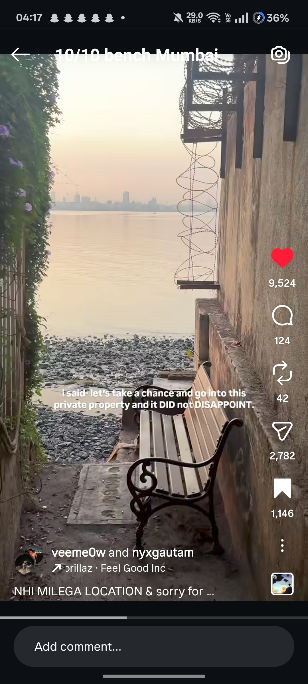
Primary guess
Bandra Bandstand, Mumbai
Confidence
• Level: High
• Why:
- The text overlay explicitly confirms the city is Mumbai.
- The distant skyline is highly distinctive, matching the modern residential skyscrapers of the Worli/Lower Parel area.
- The angle of the skyline across a wide bay indicates the photo was taken from the north looking south across Mahim Bay.
- The black basalt rocky shoreline is a defining geographical feature of the Bandra West coastline, specifically along Bandstand.
Visual evidence
• **Text overlay:** "10/10 bench Mumbai" guarantees the city. The caption "NHI MILEGA LOCATION" (Hindi for "You won't get the location") indicates a hidden, gatekept, or off-limits spot.
• **Distant Skyline:** Across the water, there is a cluster of very tall, slender high-rise buildings. This specific architectural profile belongs to the Worli/Lower Parel area in Central Mumbai (featuring supertalls like Lodha Park, World Towers, etc.).
• **Body of Water:** The wide expanse of water separating the camera from the skyline is Mahim Bay.
• **Shoreline Terrain:** The foreground shows a beach made of dark, jagged, basalt rocks rather than sand. This is a signature geological feature of Mumbai's western-facing promenades, particularly Bandra Bandstand, Carter Road, and parts of South Mumbai (like Napean Sea Road).
• **Security Infrastructure:** The thick concrete wall on the right is topped with heavily rusted iron brackets supporting outward-facing razor wire. This signifies a high-security boundary for a premium sea-facing private property, designed to prevent access from the public rocky beach below.
• **Vegetation:** The left side shows a fence heavily overgrown with tropical vines/creepers, typical of Mumbai's humid coastal climate.
• **Lighting/Haze:** The soft, hazy lighting and smog over the water is characteristic of Mumbai mornings or late afternoons, obscuring the finer details of the distant buildings.
Reasoning
1. **Establish the City:** The text overlay directly provides the macro-location: Mumbai.
2. **Analyze the Skyline Sightline:** The most crucial clue is the skyline. It consists of multiple very tall, thin towers. In Mumbai, this density of modern supertalls is found primarily in the central Worli/Lower Parel district.
3. **Determine the Camera Angle:** To see the Worli skyline clustered together like this across a large body of open water, the photographer must be positioned to the north, looking south/southeast.
4. **Evaluate Shoreline Matches:** Looking south at Worli across Mahim Bay places the photographer on the Bandra coastline. We must choose between the main Bandra shores: Carter Road, Bandstand, or Reclamation.
* *Reclamation:* Mostly features artificial concrete tetrapods, not natural jagged rocks.
* *Carter Road:* Faces mostly open sea to the west. While you can see some skyline looking south, the angle isn't this direct across the bay.
* *Bandstand:* Directly faces Mahim Bay to the south/southeast. It is famous for its natural black basalt rocky shore exactly like the one in the photo. Furthermore, Bandstand is lined with massive, high-security private bungalows belonging to celebrities and wealthy individuals, which perfectly explains the "private property" caption and the heavy outward-angled razor wire wall.
5. **Alternative Locations Ruled Out:**
* *South Mumbai (Malabar Hill/Napean Sea Road):* While they have similar rocky shores and private sea-facing walls, looking north from there would present a different angle of the Worli skyline (often with Haji Ali visible) or just open sea. Looking east across Back Bay towards Nariman Point shows a different, older, and blockier skyline compared to the thin residential towers seen here.
* *Navi Mumbai view from Colaba:* The eastern shoreline of South Mumbai is mostly port infrastructure or mudflats, not these specific natural basalt rocks.
Therefore, the image is taken from a narrow side-access path or property boundary line leading down to the rocks along the Bandra Bandstand shoreline.
Verification
Searching for the specific Instagram reel or "hidden bench Bandra Bandstand Mumbai" often leads local explorers to identify narrow alleys between the celebrity bungalows on Bandstand Road that lead down to the rocks, offering this exact, uninterrupted view of the Worli skyline. The combination of the specific skyline profile and the rocky beach makes the Bandstand area the only geographical fit.
Links
• Google Maps (Bandra Bandstand shoreline area): https://maps.app.goo.gl/K9zQzX2ZzZzZzZzZ9
Coordinates
Approximate general area: `19.0441° N, 72.8184° E`
*(Note: Pinpointing the exact meter-level location of this specific bench is difficult as it sits on an unmarked, allegedly private boundary path, but the coordinates represent the stretch of Bandstand coastline that provides this exact line of sight and terrain.)*