Blaenau Ffestiniog, Gwynedd, North Wales, UK
2026-05-07 12:59:47
Primary guess
Primary guess: Blaenau Ffestiniog, Gwynedd, North Wales, UK
Confidence
• Level: High
• Why:
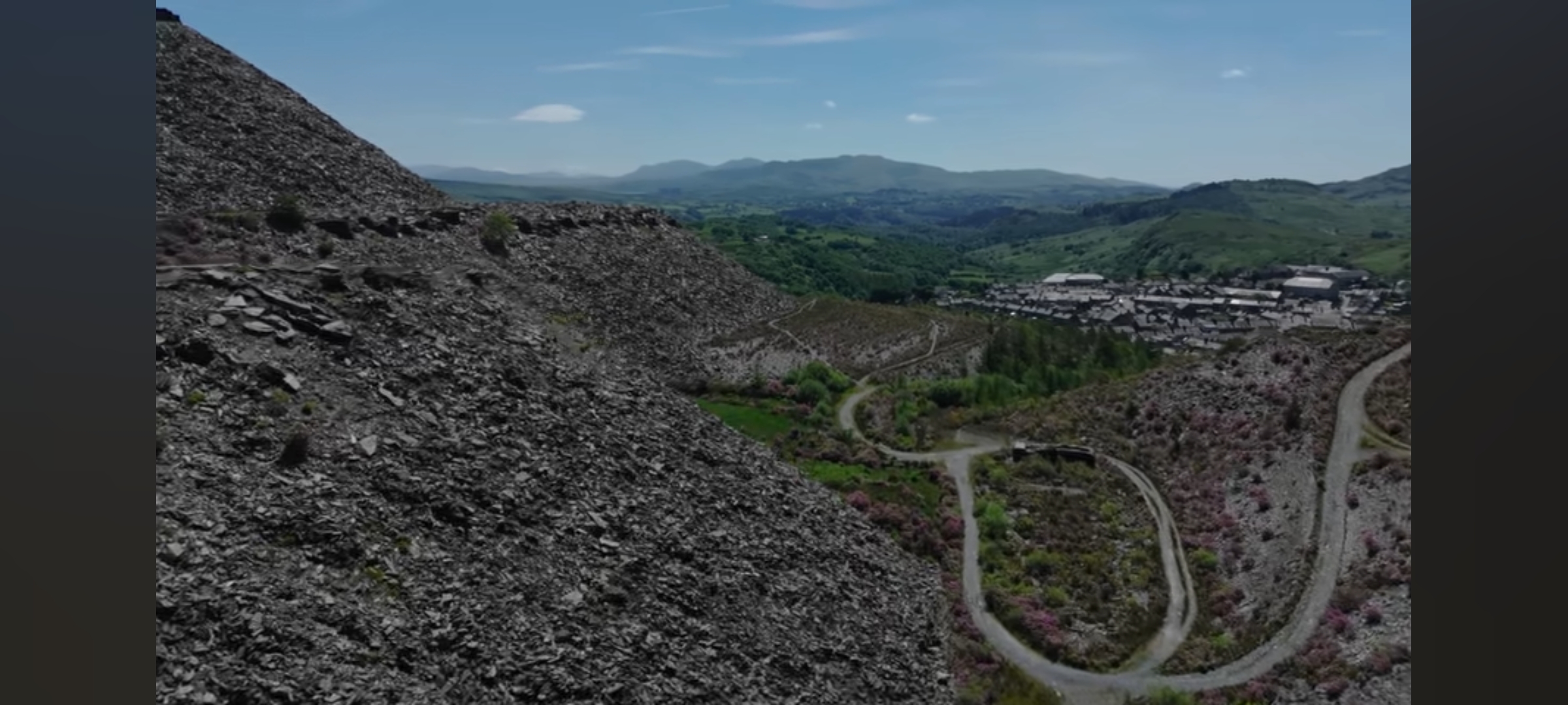
- The landscape is dominated by massive blue-grey slate waste tips (spoil heaps), which are the defining feature of the "Slate Landscape of Northwest Wales" UNESCO World Heritage site.
- Blaenau Ffestiniog is the most iconic "slate town" where the industry is physically intertwined with the urban area.
- The town's architecture, featuring dense clusters of grey slate-roofed terraced houses, is characteristic of this region.
- The winding gravel tracks match the well-known "Antur Stiniog" downhill mountain biking trails and the "Zip World Llechwedd" access roads.
- The profile of the distant mountains matches the Moelwynion range (Moelwyn Mawr/Bach) south of the town.
Visual evidence
• **Slate Waste Tips (Spoil Heaps):** Huge mounds of dark grey/blue broken rock. This is the unmistakable "waste" from the 19th-century slate mining industry in North Wales.
• **Urban Architecture:** The town in the valley consists of slate-roofed terraced housing, standard for Gwynedd mining towns like Blaenau Ffestiniog or Bethesda.
• **Terrain:** Steep, rugged valley sides transitioning into green, rolling peaks in the distance (typical of the Snowdonia/Eryri region).
• **Hairpin Track:** A well-maintained gravel road with a distinct hairpin bend in the mid-ground. This is part of the uplift/access road network for the **Antur Stiniog** mountain bike park and **Zip World Llechwedd**.
• **Vegetation:** Patches of purple heather and low-lying shrubs amidst the slate rubble, common in the North Welsh uplands.
Reasoning
The combination of vast slate waste heaps overlooking a dense town of grey-roofed buildings narrows the location to the North Wales slate belt. The primary candidates are Blaenau Ffestiniog, Llanberis (Dinorwig), and Bethesda (Penrhyn).
The specific layout—a large town nestled directly under multiple massive tiers of slate waste—is unique to **Blaenau Ffestiniog**. In Llanberis, the town is separated from the quarry by a lake (Llyn Padarn/Peris). In Bethesda, the quarry is largely a single deep pit to the side of the town. Blaenau Ffestiniog, however, is famously "surrounded by slate."
The photo is taken from the hills to the north (the **Llechwedd** or **Maenofferen** area), looking south across the town towards the **Moelwyn** mountains. The hairpin track in the foreground is characteristic of the modern tourist adaptations of the quarries, specifically the roads used by the Zip World "Quarry Explorer" vehicles and the Antur Stiniog mountain bike uplift service.
Verification
• **UNESCO World Heritage:** The Slate Landscape of Northwest Wales was designated a UNESCO site in 2021, with Blaenau Ffestiniog (specifically the Ffestiniog component) being a core part.
• **Zip World / Antur Stiniog:** Photos from Antur Stiniog and Zip World Llechwedd confirm the same grey slate vistas and winding access tracks overlooking the town.
• **Google Maps/Earth:** Satellite imagery shows the exact network of tracks on the tips north of the town, including the hairpin road at approximately 53.001, -3.932.
Links
• Google Maps - Blaenau Ffestiniog View
• Antur Stiniog Official Site
• UNESCO Slate Landscape
Coordinates
53.0011, -3.9317 (Approximate location of the hairpin bend in the foreground)