Emilia-Romagna, Italy
2026-04-28 21:54:15
Primary guess
Primary guess: Emilia-Romagna, Italy
Confidence
• Level: Low
• Why:
- The image contains no distinct landmarks, street signs, or recognizable commercial names.
- The architectural style of the buildings and the municipal infrastructure (paving) are generic to many suburban and peri-urban areas across Northern and Central Italy.
- The flat terrain and agricultural field adjacent to residential developments strongly point to a broad geographic region (such as the Po Valley or Adriatic coastal plain) rather than a single specific town.
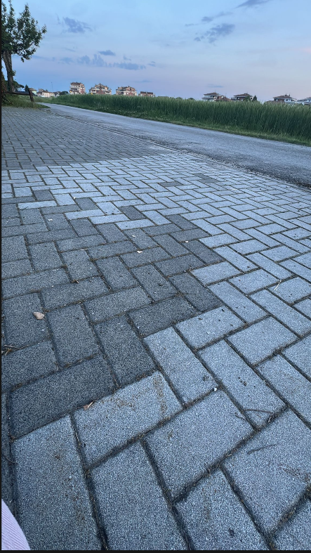
Visual evidence
• **Architecture**: The background features multi-story residential buildings (commonly referred to as "palazzine" or "condomini" in Italy). They have pitched roofs (likely with terracotta tiles), plastered facades in neutral or pastel colors, and prominent balconies. This is standard post-1970s Italian suburban architecture.
• **Infrastructure (Paving)**: The sidewalk is made of interlocking concrete pavers (known as "autobloccanti") laid in a herringbone pattern. The specific shape, two-tone grey coloring, and pattern are extremely common in Italian municipal public works and sidewalks.
• **Infrastructure (Road)**: The asphalt road lacks a raised curb on the side bordering the field. This is typical of provincial or rural roads that have been enveloped by expanding suburban areas, where a pedestrian path is added to one side.
• **Topography**: The landscape is completely flat, lacking any hills or mountains in the background, which narrows down the geographic possibilities significantly.
• **Vegetation**: A large field of green crops (likely unripe winter wheat or barley) directly abuts the road. This indicates a typical urban-rural fringe common in heavily agricultural plains.
Reasoning
1. **Identifying the Country**: The strongest visual cues are the architecture and the sidewalk paving. The specific style of the apartment blocks (pitched tiled roofs, specific balcony styles, clustered layout) combined with the ubiquitous herringbone interlocking paving strongly points to Italy. While similar individual elements might be found in Spain, southern France, or the Balkans, the synthesis of these specific design choices is distinctly Italian.
2. **Narrowing the Region**: The defining geographic feature is the absolute flatness of the terrain, combined with the juxtaposition of an agricultural field right on the edge of relatively dense, multi-story housing. This landscape is a hallmark of the Pianura Padana (Po Valley) and the Adriatic coastal plains (encompassing regions like Emilia-Romagna and Veneto). Hilly or mountainous regions of Italy can be confidently ruled out.
3. **Why a precise location is impossible**: The photograph captures a very generic, almost liminal space at the outer edge of a town. Because there are no recognizable landmarks, commercial signage, unique geological features, or readable text, pinpointing the exact municipality or street is not feasible. The distinct dark patch on the sidewalk appears to be a repair or a different batch of pavers, which is not a feature indexable on standard satellite imagery or street view without prior knowledge of the location.
Verification
A precise location cannot be verified as the image lacks unique identifiers. The visual evidence points broadly to a specific type of landscape in Italy rather than a singular, searchable landmark.
Links
• Google Maps - Emilia-Romagna region (Representative region showing the typical flat topography and dense urban-rural boundaries seen in the image).
Coordinates
Not possible to determine. The image lacks the unique, identifiable landmarks or specific geographic context necessary to deduce precise latitude and longitude coordinates. The scene could be situated on the outskirts of hundreds of different towns across the Northern Italian plains.