Masasa Beach, Tingloy, Batangas, Philippines
2026-05-25 14:02:11
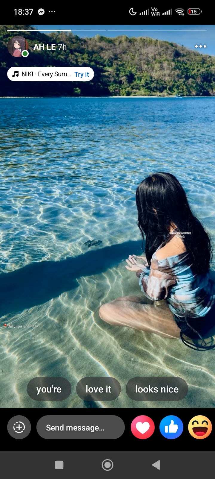
Primary guess
Primary guess: Masasa Beach, Tingloy, Batangas, Philippines
Confidence
• Level: Medium
• Why:
* The location tag "Batangas province" confirms the general area.
* The visual characteristics—exceptionally clear, shallow turquoise water over white sand with a backdrop of lush, steep tropical hills—are highly characteristic of the island municipality of Tingloy (specifically Masasa Beach or the nearby Sombrero Island).
* The presence of what appears to be a sea turtle hatchling (pawikan) is consistent with Batangas' status as a known nesting ground and marine sanctuary area.
* Masasa Beach is a very popular "aesthetic" destination for social media users in the Philippines, matching the style of the screenshot.
Visual evidence
• **Water clarity and color:** Crystal clear, turquoise-to-blue gradient, indicating shallow, clean water over light-colored sand. This is a hallmark of Tingloy and Verde Island in Batangas.
• **Geography:** Steep, densely vegetated green hills in the background. This fits the volcanic and hilly terrain of Maricaban Island (where Tingloy is located).
• **Marine life:** A small sea turtle hatchling is visible in the shallow water. Batangas is a major conservation area for sea turtles (e.g., in Calatagan, Nasugbu, and Tingloy).
• **Vessel:** A faint outline of a traditional Filipino "bangka" (outrigger boat) can be seen in the distance, confirming the Philippine setting.
• **Text overlay:** The tag "Batangas province" with a red location pin is a standard Facebook/Instagram location sticker.
• **Language:** The text "IHHH SWIMMING PA NAA" uses Tagalog/Filipino informal language ("Swimming pa na" means "Still swimming"), which is typical for a local tourist's post.
• **Climate/Vegetation:** Tropical forest on the hills and bright, direct sunlight suggest a tropical environment, consistent with the Philippine summer season (March-May).
Reasoning
The process began by identifying the explicit text "Batangas province," which narrowed the search to one province in the Philippines. I then analyzed the unique landscape: very clear, shallow water with a large hill directly adjacent.
In Batangas, there are several key areas with this look:
1. **Tingloy (Masasa Beach / Sombrero Island):** This is the strongest candidate. Masasa Beach is famous for its "crystal clear" water and is surrounded by high, lush hills. It is a top destination for the kind of "sitting in shallow water" photos shown here.
2. **Nasugbu (Coves like Bituin or Santelmo):** These areas also have clear water and steep hills, but they are often private or harder to access than Masasa.
3. **Calatagan:** While Calatagan has clear shallow water (often called "Little Boracay"), the landscape is generally flatter, and the hills are further across the bay.
4. **Verde Island:** Known for incredible water clarity, but the shoreline is often rockier or has a steeper drop-off compared to the wide shallow area shown.
The combination of the shallow sandy floor, the proximity and height of the background hill, and the commonality of sea turtle sightings in the region makes **Masasa Beach** in Tingloy the most likely specific location.
Verification
• **Geography:** Comparing the background hill to photos of Masasa Beach shows a strong match for the terrain of Maricaban Island. Example of Masasa Beach scenery
• **Turtle Sightings:** Search results confirm that sea turtles are frequently sighted by tourists at Masasa Beach and that conservation efforts are active in the Tingloy area. Tingloy Pawikan Conservation
• **Location Tag:** The "Batangas province" tag is the most common broad tag used for these islands.
Links
• Google Maps - Masasa Beach
• Tingloy, Batangas Tourism Page
Coordinates
13.655883, 120.875323 (Approximate location of the shoreline at Masasa