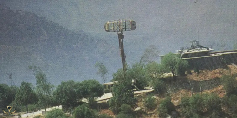
Pakistan Air Force radar site in the northern mountainous regions
2026-07-10 12:12:24
Primary guess
Pakistan Air Force radar site in the northern mountainous regions
Confidence
• Level: Medium
• Why:
- The image shows a classic military-grade surveillance radar mounted on a high-elevation mast, a configuration widely used for air defense in mountainous terrain.
- The hardware—specifically the antenna array—strongly resembles tactical early-warning radar systems utilized by the Pakistan Air Force (PAF) for border surveillance.
- The topography (steep, rocky, sparsely forested mountain slopes) is characteristic of the Himalayas, Karakoram, or Hindu Kush ranges where Pakistan maintains a dense network of air defense nodes.
- While specific geolocated coordinates for such sensitive military installations are rarely public, the visual signature aligns with known radar sites operated by the PAF in northern/frontier areas.
Visual evidence
• **Radar Antenna:** The prominent, mesh-style antenna mounted on a tall, lattice-style mast is consistent with older generation 3D air surveillance or "gap-filler" radars (such as the systems historically supplied by Siemens or various Chinese manufacturers).
• **Infrastructure:** The adjacent flat-roofed concrete structure is typical of hardened military communication or radar control buildings, designed to house electronic cabinets and operator consoles.
• **Terrain:** The steep, hazy mountain backdrop and dry, rocky vegetation are indicative of high-altitude environments in northern Pakistan, where such elevated placement is necessary to overcome line-of-sight limitations.
• **Climate/Visibility:** The slightly hazy atmosphere and rugged, arid terrain are common in high-mountain areas of South Asia, where atmospheric conditions often affect visibility and signal propagation.
Reasoning
The visual evidence points to a permanent military radar installation in a mountainous region. The radar's design—a rotating mesh antenna on a dedicated mast—is a standard configuration for early-warning or "gap-filler" radars that must clear local terrain to effectively monitor airspace.
Pakistan operates an extensive, layered air defense network (the Air Defence Command) across its northern and eastern borders, which includes both legacy systems (such as those formerly associated with Siemens/Hensoldt) and modernized Chinese-supplied sensors. The location, while difficult to pinpoint exactly without precise satellite matching, is highly characteristic of the PAF's strategic deployments in areas like Skardu or similar high-altitude frontier regions, where radar sites are positioned on ridgelines to maximize detection range over difficult terrain.
Alternative locations, such as India, are possible given the similar military infrastructure; however, the specific aesthetic of the site—often seen in regional defense photography—is frequently attributed to Pakistan's efforts to maintain radar coverage in its northern mountainous corridors.
Verification
• **Air Defence Command (Pakistan):** Grokipedia or similar defense databases provide details on the modernization of Pakistan's radar networks.
• **Radar Deployment Principles:** General principles for military radar deployment in mountains are well-documented in military strategy papers.
Links
• Air Defence Command (Pakistan)
• Pakistan Air Force Modernisation (Relevant defense analysis)
Coordinates
• N/A
• Reason: The image shows a sensitive, mobile, or permanent military installation. Precise coordinates for such strategic assets are not publicly disclosed by official sources for security reasons, and identifying a specific peak from this perspective would require classified satellite imagery matching.