Roof terrace of St. Peter's Basilica (Terrazza di San Pietro), Vatican City
2026-05-09 14:49:27
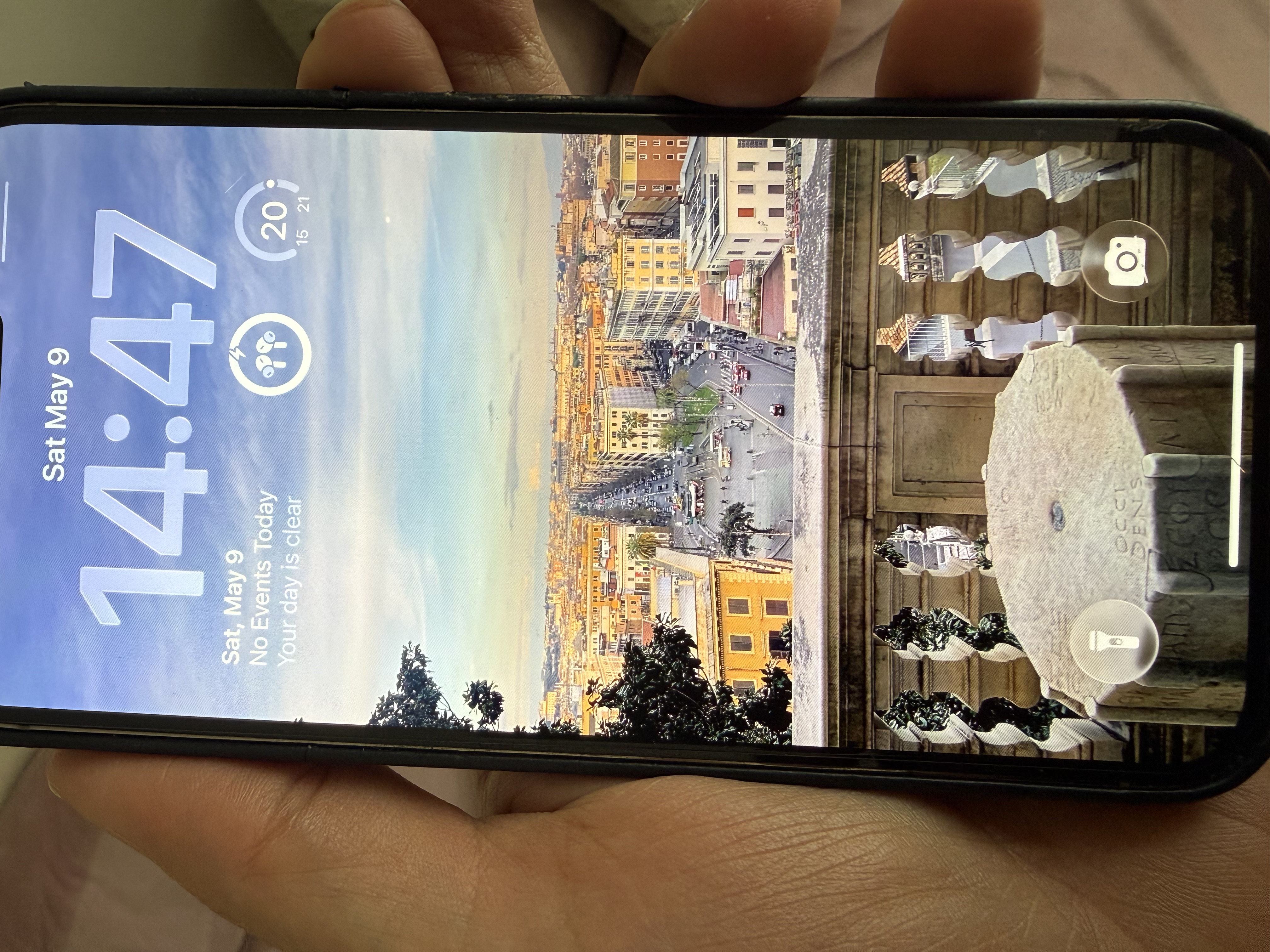
Primary guess
Primary guess: Roof terrace of St. Peter's Basilica (Terrazza di San Pietro), Vatican City
Confidence
• Level: High
• Why:
* The view shows the unmistakable Via della Conciliazione, the main boulevard leading to St. Peter's Square.
* The perspective and height perfectly match the roof terrace (loggia) level of St. Peter's Basilica, where visitors can walk behind the facade statues.
* The stone marker in the foreground with the Latin inscription "OCCIDENS" (West) is a known wind/direction marker located specifically on this terrace.
* The architectural style of the surrounding Borgo district is distinctively Roman.
Visual evidence
• **Via della Conciliazione:** The long, straight boulevard in the center of the image is the primary approach to the Vatican from the Tiber river.
• **"OCCIDENS" Stone:** A stone pedestal/marker in the foreground with the Latin word for "West." This is one of several wind rose markers on the roof terrace of St. Peter's.
• **Balustrade:** The travertine stone railing with classic balusters matches the architecture of the Basilica's facade.
• **Roman Architecture:** The buildings flanking the street feature the typical ochre and yellow hues, flat facades, and terracotta tiled roofs of central Rome.
• **Distant Landmarks:** At the far end of the street, the trees lining the Tiber river and the white structure of Ponte Vittorio Emanuele II are visible.
• **Climate/Time:** The clear blue sky, soft afternoon light, and temperature widget (20°C) are consistent with a mid-afternoon in Rome in May.
Reasoning
The alignment of the street is the most significant clue. **Via della Conciliazione** is a unique, perfectly straight wide boulevard that runs East-West between the Tiber river and St. Peter's Square. The camera is looking **East** down this street.
The viewpoint's elevation and proximity to the start of the street indicate it was taken from the **facade or roof level of St. Peter's Basilica**. While there is a higher view from the dome (cupola), the angle here is lower, looking through the balustrade of the terrace level (often reached by elevator before climbing to the dome).
The stone marker labeled **"OCCIDENS"** (Latin for West) confirms the location and orientation. On the roof terrace of the Basilica, there are stone markers indicating the points of the compass. Since the camera is looking East toward the city, the "West" marker is positioned such that its side facing the viewer indicates the direction behind them (the Basilica itself).
Verification
Photos of the roof terrace of St. Peter's Basilica consistently show these octagonal stone markers and the exact view down Via della Conciliazione.
• View from the roof of St. Peter's Basilica
• Wind rose markers on St. Peter's roof (Note: While the primary wind rose is in the square, there are corresponding markers on the terrace level).
Links
• Google Maps - St. Peter's Basilica
• Wikipedia - Via della Conciliazione
Coordinates
41.9021, 12.4549 (Approximate location on the roof terrace above the facade).