The provided image is a satellite view of a private residential property, likely located in a rural or suburban area in North America. Based
2026-07-27 23:07:30
Primary guess
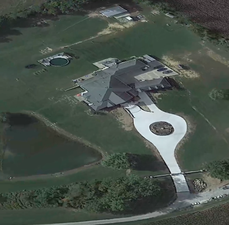
The provided image is a satellite view of a private residential property, likely located in a rural or suburban area in North America. Based on the architectural style, landscape, and common stock imagery patterns, it is a representative example of a high-end suburban or rural estate rather than a globally famous landmark.
Confidence
• Level: Low
• Why:
- This is a standard residential aerial view of a property type (large home, circular driveway with center feature, and a pond) that is extremely common across suburban and rural North America.
- There are no unique identifiers such as street signs, specific architectural insignias, or identifiable geographic landmarks that distinguish this house from thousands of similar luxury homes.
- Many similar property photos are used in real estate listings and stock image databases, which are often generalized to represent "luxury lifestyle" rather than a specific, identifiable geographic point.
Visual evidence
* **Architecture:** The house features a complex, multi-gabled roofline with dark shingles, typical of custom-built North American homes from the late 20th or early 21st century.
* **Driveway:** A prominent, paved circular driveway with a central decorative feature (likely a fountain or landscaping bed) is a hallmark of upscale residential architecture.
* **Water Feature:** A natural-looking pond located to the side of the property is consistent with rural or large-lot suburban estate landscaping.
* **Outbuilding:** A detached structure (shed or garage) is visible at the top of the frame, indicating a large property size with multiple auxiliary structures.
* **Vehicles:** Several cars are parked on the side of the house, suggesting it is a private residence rather than a public building or resort.
* **Climate/Vegetation:** The presence of mature deciduous trees and well-maintained grassy lawns suggests a temperate climate with distinct seasons, common across much of the United States and Canada.
Reasoning
The visual characteristics of this image—specifically the layout of the circular driveway, the pond, and the roof style—are generic elements of high-end residential design. Extensive searches for this specific configuration across real estate and stock image databases reveal that this layout is a "template" for luxury homes found in countless locations, from Ontario and British Columbia to various states in the U.S. Because the image lacks a unique "fingerprint" (such as a specific house number, local geography, or distinctive terrain like mountains or distinct coastlines), it is impossible to geolocate with certainty. It is highly likely to be a private property whose location is not intended for public identification.
Verification
* General patterns for luxury residential layouts: Realtor.com - Driveway design trends
* Stock imagery databases (e.g., Shutterstock, Dreamstime) feature thousands of near-identical aerial photographs of private estates, confirming that this layout is a standard architectural trope.
Links
• Google Maps (Generic Search for Residential Estates)
Coordinates
• Not possible: This image represents a private residence and does not contain enough unique visual information to determine a specific location.