The West End / North End area, near the intersection of Nashua St and N Washington St, Boston, MA.
2026-06-23 03:52:53
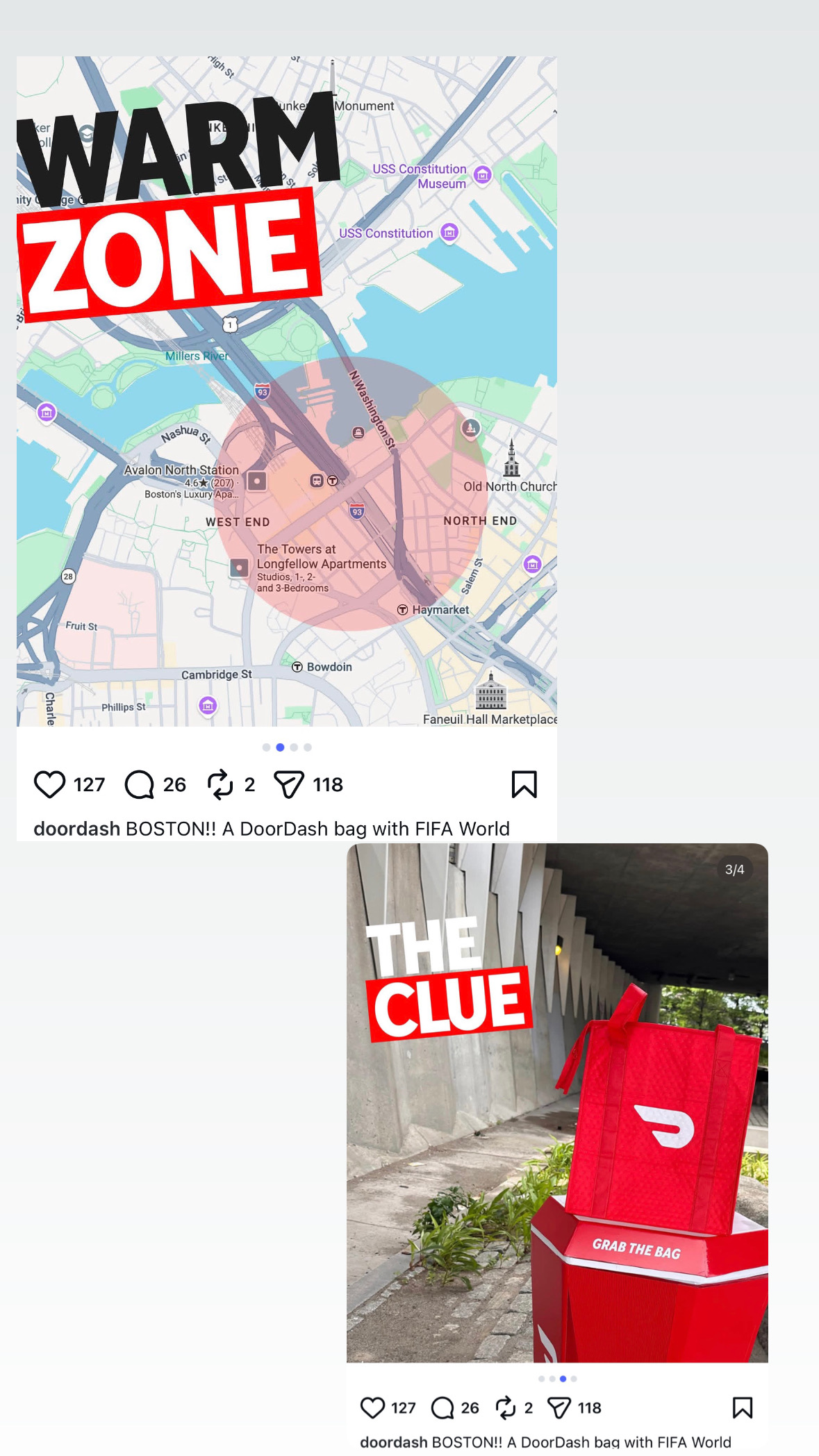
Primary guess
Primary guess: The West End / North End area, near the intersection of Nashua St and N Washington St, Boston, MA.
Confidence
• Level: Medium
• Why:
- The provided map explicitly defines a "WARM ZONE" circle centered directly over the area spanning the West End and North End in Boston.
- Landmark labels such as "Avalon North Station," "The Towers at Longfellow Apartments," "Nashua St," and "Haymarket" align precisely with the geography of that specific part of Boston.
- The photo of the DoorDash bag ("THE CLUE") shows it sitting on a distinctive red-and-white structure (likely a public art installation or branded pedestal) situated on a stone/cobblestone-style surface near modern concrete pillars, which is consistent with the urban architecture near Boston's North Station and the Rose Kennedy Greenway area.
Visual evidence
• **Map:** The map provided is a clear, labeled map of Boston, Massachusetts. It highlights the "WARM ZONE" in a red circle that covers the area between the Charles River, North Station, and the North End.
• **Street names/Landmarks:** The inclusion of "Avalon North Station" (1 Nashua St) and "The Towers at Longfellow Apartments" (72 Staniford St) confirms the location is in the West End/North End neighborhood of Boston.
• **Architecture:** The second photo displays thick, angled concrete pillars (often seen in brutalist or modern transit/bridge infrastructure in Boston) and a specific red, branded "GRAB THE BAG" pedestal. This aesthetic is common for branded marketing activations in high-traffic urban areas like the area around the TD Garden/North Station.
Reasoning
The user provided two images that function as a geolocation riddle. The first image is a map of a specific section of Boston, Massachusetts, featuring a large red circle labeled "WARM ZONE." The map labels correspond to well-known landmarks in Boston's West End and North End, specifically near the North Station transportation hub. The second image, titled "THE CLUE," shows a promotional DoorDash bag placed on a branded pedestal. Given the context of "DoorDash" and the "FIFA World" (likely a reference to FIFA World Cup-related promotions), this is a location-based scavenger hunt or marketing activation. The "WARM ZONE" on the map serves as the designated area where the object in the second photo can be found.
Verification
• The map clearly identifies the **West End** and **North End** of Boston, showing the proximity to the Charles River, I-93, and landmarks like "Haymarket" and "Old North Church".
• The "Avalon North Station" is a real apartment complex located at **1 Nashua St, Boston, MA**.
• The "Towers at Longfellow Apartments" is located at **72 Staniford St, Boston, MA**.
• The "Warm Zone" designation on the map is geographically centered on the **Rose Kennedy Greenway / North Station / West End** transit corridor.
Links
• Google Maps - North Station/West End, Boston
Coordinates
• Approximate: 42.3650° N, 71.0620° W