United Kingdom (Residential area)
2026-06-05 20:35:44
Primary guess
Primary guess: United Kingdom (Residential area)
Confidence
• Level: Low
• Why:
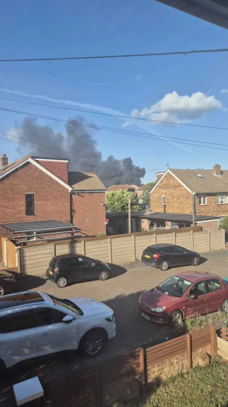
- The architectural style of the houses (brick construction with tile roofs) and the visual indicators of vehicles and street layout are characteristic of the United Kingdom, but there are no unique local identifiers (such as specific street signs, landmarks, or vehicle registration plates with clear readable data) to narrow it down to a specific town or street.
- The smoke in the background is a transient event, not a permanent geographic marker.
- While the "look and feel" is unmistakably British suburban, this design is pervasive across the country, making a precise address impossible to determine from this single image without metadata.
Visual evidence
• **Architecture:** The houses are constructed of standard red and yellow brick, common in UK suburban developments. Roofs are pitched with concrete or clay tiles.
• **Vehicles:** Several cars visible (a white SUV, a black hatchback, a red Peugeot) have UK-style long, rectangular license plates, which strongly indicates the location is in the UK.
• **Infrastructure:** The street features block paving, typical of modern or renovated UK residential developments. The fencing consists of standard concrete posts and gravel boards, which is a very common residential boundary style in the UK.
• **Climate/Environment:** The clear blue sky and typical lighting suggest a temperate climate, consistent with a fine day in the UK.
• **Incident:** There is a thick plume of black smoke in the distance. In a UK context, this often suggests a fire involving synthetic materials, rubber, or plastic (e.g., at an industrial site, waste facility, or large building), as reported in similar news incidents.
Reasoning
The process of geolocation relies on identifying unique identifiers. In this image, the primary identifiers are:
1. **Vehicle Registration Plates:** The shape and color scheme of the plates are consistent with the UK format.
2. **Housing Stock:** The combination of red-brick, semi-detached/terraced housing with concrete-post fences and block-paved driveways is emblematic of suburban Britain.
3. **Lack of Specific Markers:** There are no visible road signs, shop fronts, or unique skyline features to facilitate a search.
Because this type of residential architecture is replicated in thousands of locations across England, Scotland, Wales, and Northern Ireland, it is not possible to determine the exact address. The smoke is likely the result of a local incident (such as a factory fire or refuse blaze), which is a common subject for community-shared images but does not provide a permanent geographic anchor. Alternative locations outside of the UK are highly unlikely due to the specific combination of the license plate format and the very distinct style of British residential fencing and housing materials.
Verification
• The visual cues (brick types, license plates, concrete fence panels) align with standard UK residential areas.
• General searches for similar smoke-plume incidents confirm that such photos are frequently shared in local social media groups to report fires, but they lack specific metadata that would allow for pinpointing the exact coordinates without local knowledge or additional context.
Links
• UK Housing Architecture (General)
Coordinates
Not possible to determine. The photo captures a transient event (a fire) in a generic suburban setting with no unique landmarks, signage, or distinguishing geographic features that would permit precise triangulation.