Wibautstraat, Amsterdam, Netherlands
2026-05-02 13:43:04
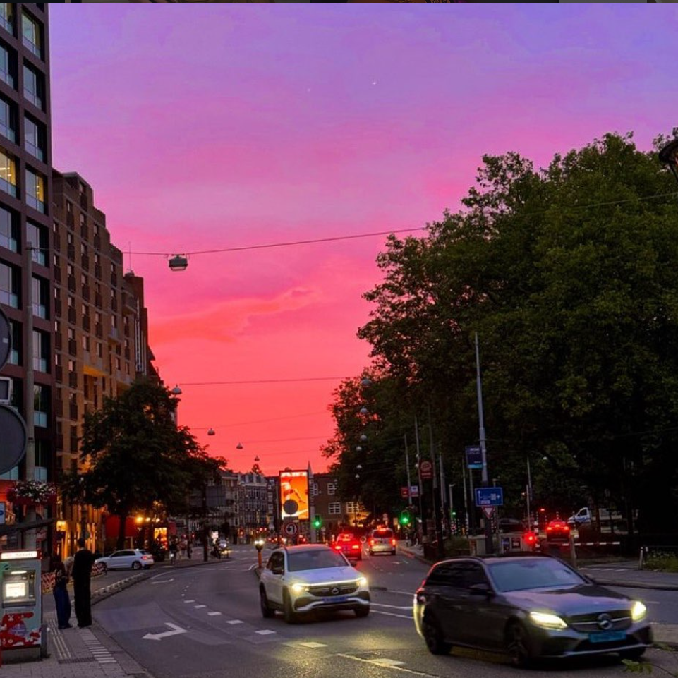
Primary guess
Wibautstraat, Amsterdam, Netherlands
Confidence
• Level: High
• Why:
- The yellow license plates are characteristic of the Netherlands.
- The parking meter on the left has the specific red and white stripe pattern used by the City of Amsterdam.
- The architecture on the left perfectly matches "The Social Hub Amsterdam City" (formerly The Student Hotel) at Wibautstraat 129.
- The wide, multi-lane road with streetlights suspended on overhead wires is a hallmark of Wibautstraat, often called Amsterdam's only true boulevard.
- The digital billboard and tree line on the right match the intersection of Wibautstraat and Mauritskade.
Visual evidence
• **License Plates:** The yellow plates with a blue EU strip on the left are the standard for vehicles registered in the Netherlands.
• **Architecture:** The building on the far left features a distinctive dark brick/cladding grid with deeply recessed windows, which is the facade of **The Social Hub Amsterdam City**.
• **Street Furniture:** The parking meter (ticket machine) on the left sidewalk has a red-and-white diagonal sticker at its base, which is the standard branding for Amsterdam's parking management.
• **Road Markings:** The large white arrow on the pavement indicates a left-turn lane, consistent with the layout of Wibautstraat at its various intersections.
• **Signage:** The blue sign on the right is a standard Dutch "P-Route" (parking guidance) sign, which typically lists central parking garages and distances.
• **Infrastructure:** Streetlights are suspended on wires across the road, a common feature in Amsterdam to keep sidewalks clear for pedestrians and cyclists.
• **Vegetation:** The dense line of mature trees on the right corresponds to the green belt along the Mauritskade/Oosterpark area.
Reasoning
The search begins by identifying the country through the **yellow license plates**, which strongly suggests the Netherlands. The urban density, specific parking meter design, and overhead streetlights narrow the location down to **Amsterdam**.
The road is exceptionally wide for a European city center, pointing towards **Wibautstraat**, known as the "Knowledge Mile." Looking North on Wibautstraat towards the city center, the west side of the street (left) contains several modern developments. The most prominent is the building at **Wibautstraat 129**, whose grid-like facade is visible on the left edge of the photo.
Further down the road, the intersection with **Mauritskade** features a large digital advertising screen (often operated by Ocean Outdoor or JCDecaux), which is visible in the center-left of the background. The trees on the right match the greenery found at the corner of the Oosterpark neighborhood. The pink sunset sky is a frequent sight in Amsterdam due to its proximity to the coast and specific atmospheric conditions.
Verification
1. **Google Street View:** A view from Wibautstraat 131 looking North shows the exact same building facade on the left, the parking meter, and the approach to the Mauritskade intersection.
2. **Architecture:** Photos of "The Social Hub Amsterdam City" confirm the grid window pattern seen on the left.
3. **Billboard:** Digital billboard locations in Amsterdam confirm a large vertical screen at the corner of Wibautstraat and Mauritskade.
Links
• Google Maps - Street View of the location
• The Social Hub Amsterdam City (Building on left)
Coordinates
52.3558, 4.9125